Official Forecast for Tonight
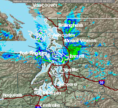
Edit 1:45pm: snowflakes are falling throughout North Seattle, and precipitation is filling into the Puget Sound with plenty of precip offshore. Forecast on track so far.
Well it took long enough.
Just three months into winter, we find ourselves in the position to see some snow throughout the region.
The pattern doesn't seem all that conducive for any widespread snow accumulations at first glance, however the potential for a decent snowfall does indeed exist for much of the Puget Sound lowlands.
Let's start off with this morning's convergence zone:

It is quite firmly planted in the Everett region for now, and will likely stay there for most of the afternoon. This feature is being brought about not by air diverging around the Olympics and meeting back in the Puget Sound, but rather by Arctic air pouring out of the Fraser River valley and meeting with southwest flow wrapping around our ULL. This is illustrated by the obvious difference in temperature between the two air masses. To the north, cold northerly winds. To the south, warmer southwesterly winds (though I must say it is NOT warm to the skin. I walked my dog today. Not fun.) And where they meet, clouds and snow.

Many areas have seen some solid accumulations. "MossMan" even has close to two inches of snow in Stanwood.

This evening, cold air will spread down throughout the Puget Sound, and by about midnight or so, everyone will be cold enough for accumulating snow down to sea level.
Keep in mind, if you're not receiving arctic outflow yet and you're seeing worm temperatures, do not worry. This isn't the air that will give you snow yet.
My Predictions
Since yesterday's blog post, models have began to soundly agree on where to put the deformation band I was discussing. Most now place this band directly over the Puget Sound lowlands, dropping snow from about 12:00am through 8:00am Monday morning. Most models agree on snow accumulations in this feature from about Everett down to Portland. Here I'm showing three of the most prominent and accurate forecast models and their predictions for snowfall totals tonight. Keep in mind that portions of this will be spent falling while it's still cooling to below freezing, or trying to cool the ground off, so these totals are a bit boosted above what they really would be:


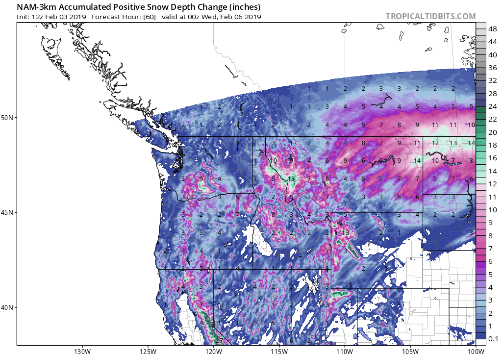
You can see that there is good agreement on some snow tonight, with a general range of 1-3in on Operational runs. These forecasts also come with good ensemble support and observation verification this morning, perhaps a delayed outflow by an hour or two, nothing major.
My best guess goes as follows:
North Sound:
A good portion of the snow accumulations here will come from this morning, especially up north. The deformation band still should reach all the way up to Lynden, however accumulations will be limited the further north you go due to lack of moisture and evaporative cooling. The PSCZ is an outlier to this rule. It could dump larger accumulations in extremely localized areas, particularly near Everett. I'm predicting a trace-2in, with localized higher amounts.
Central Sound:
The deformation band is likely to set up shop somewhere in this region. Wherever it sets up, the vertical alignment of the feature will likely cause some sharp east-west gradients in snow accumulations. In general, expect snow to start around midnight and last into the morning Monday. Some will get lucky, and others won't, however I do expect everyone to see a little snow tonight. I'm guessing 0.5-4", with large variations depending on where the band sets up. The higher end of the spectrum will favor elevations above 5-700', since temperatures initially will be too marginal for snow right down to sea level. Seattle will likely recieve 0.5-2".
Coast and Southwest:
The higher hills this afternoon will recieve some convective snow showers streaming in off the coast, amounting to small accumulations. Other than that, most will have to rely on a dying deformation zone. While the deformation band will initially form to the east, it'll eventually sag south and weaken into the region. Whatever snow this region gets from this feature will likely occur during daylight hours, so there will be some low lying areas where snow is either sloppily accumulating or not accumulating at all. Despite this, residual moisture should be just enough for a few inches over a broad area as the decaying deformation band slowly drags south. All in all, 0-3" is my predication; more eastward and with elevation.
Port Angeles and co.
This region is where I'm watching closely for some serious accumulations, as a long term heavy snowfall event is appearing more and more likely. Cold air streaming in from the Fraser River valley will slam into the Olympics and rise, forcing clouds and snow showers. This has the potential to last for multiple hours, starting this afternoon and extending into midday tomorrow. A sharp north-south snow gradient will occur tonight, favoring those with proximity to the Olympic Mountains. I think it's fair to say that this region will receive anywhere from a trace-8"+, with less near Sequim and more towards the Port Angeles foothills.
Regarding Winds
The straight and the North Sound will experience some serious winds tonight into Monday. Wind gusts will approach 50mph, with sustained winds near 25mph. Despite the wind speeds being more usual than not for this region, the direction won't be, and some trees will likely fall as they're pushed at their stress points. To make things worse, this air will be cold, bringing wind chills down to below zero in a few exposed locations. Bundle up and stay safe.
This is an incredibly difficult forecast with lots of variables. The bust potential on this forecast is extremely high, however with model and satellite verification continuing, this forecast looks like a pretty good bet for the next 24 hours.
Whatever accumulates tonight should stay with us through the week. Some models have us remaining below freezing both tomorrow and Tuesday, as arctic winds scream out of the north over a snowy landscape. Our next chance of snow exists this Thursday-Saturday, with a potential for high amounts. Stay tuned.

Las Vegas' Wynn Casino - JTM Hub
ReplyDeleteCasino. Wynn communitykhabar is a $4 billion resort wooricasinos.info with four 출장안마 hotel towers with novcasino 5,750 rooms and suites. Each of the hotel towers includes a 20,000 square foot casino and a