Detailed Thoughts on Upcoming Snow Event
Superbowl 51, two years ago.
With less than four minutes to go in the third quarter, the Falcons punt the ball away to Tom Brady after burning several minutes of clock crucial to the Patriots, whilst they lead 28-3; a seemingly insurmountable lead only matched by Seattle two years prior and Dallas in 1994. Atlanta is already celebrating, justifiably.
Impartial to the incredible, inconceivable comeback about to ensue, I lay motionless beside my dining room, waiting for a sign. Any sign.
It's 34F outside. Locations 500' and higher above sea level are getting pounded, and here I am, stuck in the lowlands, watching an equivalently inconceivably marginal drizzle taunt me.
That day, I missed the greatest Superbowl of all time. And I got 1.5" of snow out of it; the lowest total in all the lowlands. Issaquah, just a half an hour's drive away, received more than 10".
It is the single greatest meteorological robbery I have ever experienced.
Ominously, the Patriots are playing again this year. Go figure.
It is becoming increasingly clear that we are having yet again another Superbowl that will be distracted by an unfolding snow event. I'm just hoping that the game this year won't be nearly as good as it was two years ago.
This morning's satellite imagery shows us the overall synoptic pattern unfolding.

With less than four minutes to go in the third quarter, the Falcons punt the ball away to Tom Brady after burning several minutes of clock crucial to the Patriots, whilst they lead 28-3; a seemingly insurmountable lead only matched by Seattle two years prior and Dallas in 1994. Atlanta is already celebrating, justifiably.
Impartial to the incredible, inconceivable comeback about to ensue, I lay motionless beside my dining room, waiting for a sign. Any sign.
It's 34F outside. Locations 500' and higher above sea level are getting pounded, and here I am, stuck in the lowlands, watching an equivalently inconceivably marginal drizzle taunt me.
That day, I missed the greatest Superbowl of all time. And I got 1.5" of snow out of it; the lowest total in all the lowlands. Issaquah, just a half an hour's drive away, received more than 10".
It is the single greatest meteorological robbery I have ever experienced.
Ominously, the Patriots are playing again this year. Go figure.
(End of interlude)
Oh boy.
It is becoming increasingly clear that we are having yet again another Superbowl that will be distracted by an unfolding snow event. I'm just hoping that the game this year won't be nearly as good as it was two years ago.
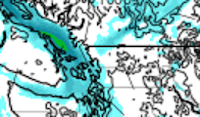
This morning's satellite imagery shows us the overall synoptic pattern unfolding.

Yesterday's front has since translated its way eastward, leaving us in a break between storms. The blue region directly to our north and east does not signify clouds, but rather cold air moving southward through British Colombia. This is the cold air we will be dealing with tomorrow night.
Upon closer inspection, we find a broad area of low pressure a good 1,000 miles offshore. This will weaken considerably this afternoon, and move into northern California as a batch of energy, giving them decent precipitation. In its place, a large region of high pressure will fill the gap. This will create the blocking necessary for the cold air in British Colombia to dive southward into our region.
Okay, that's good so far, but we still need to analyze those pesky computer forecasts.
Models have been all over the place in the past few days, and therefore I've been reluctant to post anything in regards to forecasts, or even updates. Run after run of each model has brought flip after flip and contradiction after contradiction, as expected with these kinds of events. Posting any sort of updates would be a fools errand, unless you actually find joy in posting corrections every other batch of returns.
Recently, models have began to latch on to a general idea of what will occur tomorrow night regarding mesoscale features, cold air intrusion, and ULL forcing and placement.
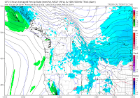
To start off the fun, around 10pm tonight, Fraser outflow will begin as a result of rapidly developing blocking. It is present on this morning's HRRR run, as seen here:


Okay, that's good so far, but we still need to analyze those pesky computer forecasts.
Models have been all over the place in the past few days, and therefore I've been reluctant to post anything in regards to forecasts, or even updates. Run after run of each model has brought flip after flip and contradiction after contradiction, as expected with these kinds of events. Posting any sort of updates would be a fools errand, unless you actually find joy in posting corrections every other batch of returns.
Recently, models have began to latch on to a general idea of what will occur tomorrow night regarding mesoscale features, cold air intrusion, and ULL forcing and placement.
To start off the fun, around 10pm tonight, Fraser outflow will begin as a result of rapidly developing blocking. It is present on this morning's HRRR run, as seen here:


You can watch the progress of that little finger of wind spreading from the opening of the valley all the way to the Sound.
Just because this is Fraser outflow doesn't necessarily mean there will be instantaneous arctic air intrusion. As of 3:30pm today, temperatures in the valley are close to 40F about 100 miles inland into the mountains. We will have to wait until later tomorrow morning before any strong, cold outflow intrudes the Puget Sound lowlands.
In the meantime, the beginnings of an upper-level low heading south along the coast of British Colombia will form a depression over Vancouver Island. By about 5:00am, the area of disturbance will slowly drag south and onto the waters off the coast of Washington. This will coalesce into an upper-level low, and by 10:00am, spotty showers will begin to affect the region, all the while cold air screams out of the valleys of British Colombia and into the strait of Haida Gwaii. Wrapping around the low, the imported Canadian air will cool off the disturbance substantially, lowering snow levels across the region.


Hampering the cooling efforts will be the moderation of the air caused by the Pacific Ocean. This will prevent the lowlands from receiving snow until after dark, save for the Northern Sound, where outflow will turn cold sometime in the mid morning and meet with pacific flow, causing convergence.
By around 4:00pm, cold Fraser outflow will begin to cool off the rest of the lowlands, however it won't be instantaneous. Temperatures cold enough for accumulating snow could very well hold off until 8:00pm or later.


Big Note:
This Fraser outflow will present a real threat for moderate to large snow accumulations along the northern slopes of the Olympic Mountains. As the cold outflow hits the Olympics, it is forced to rise, cool, and condense, producing a steady, consistent stream of heavy snow showers that can last for an extended period of time. This area will have to be assessed particularly closely. Additionally, they will gt quite fierce heading into the overnight hours, with gusts possibly approaching 50mph. These winds can knock over trees and damage property, especially when they're come from such an unusual angle.


Occurring simultaneously to this cooling effect, our ULL off the coast will become elongated as it bottoms out around 995mb. This is a first for me, and even though I've only been tracking snow events for a few years now, I still have a hunch this sort of structure in this kind of event isn't all that common.

More relevant to the Western Washington lowlands, a deformation zone will form after dusk. This is a complicated feature that has the potential to dump quite a bit of moderate to heavy snow over a localized area, while leaving others nearby completely untouched.
This feature will form on the underside of the ULL as a shortwave off the coast of Washington and Oregon. This minor disturbance will retrograde around the low Northward, just as the low itself begins to resume its meandering down the coast.
The contradiction between the shortwave's forward momentum and the ULL's southern ambitions will force the air over this shortwave to stretch, causing diffluence in the atmosphere, and henceforth lift, condensation, and precipitation; right as temperatures are cooling down. (The following graphics below aren't depicting exactly where I think they'll go. More on that later.)


Models have been having an extremely difficult time on pinning down where this feature will form, and for how long it will last. They are, however, confident in temperatures, and it's apparent that temperatures will be soundly cool enough for accumulating snow down to sea level, with 500mb thickness values below 1300m. As mentioned before, those who are affected by this feature could pull out a solid layer of snow tomorrow night.
I've gathered a bunch of different models and highlighted where they put the band:
 |
| WRF |
 |
| GFS |
 |
| FV3 GFS |
 |
| ICON |
 |
| ECMWF |
 |
| GEM |
 |
| HRRR |
 |
| NAM |
 |
| RGEM |
 |
| NMM |
 |
| HRDPS |
 |
| ARW |
As you can see quite clearly, this is a complicated and difficult forecast, amplified by model variability and disagreement. Some models take it west. Some models take it East.
Some models take it right overhead. And one even scraps the idea of a deformation band and just brings in snow showers.
What do I think?
Personally, I'm waiting until tomorrow before I make any forecasts. But I will say I am certainly skeptical about a few models and the way they handle the cold air and precipitation. And I do think both the Seattle and Portland metro will see some flakes.
It still could be nothing or two inches.
I will update tomorrow when we have a better idea with a forecast, or god forbid it be necessary, a model change review.
Good luck, and stay informed.
Comments
Post a Comment