Posts

Update to Predictions

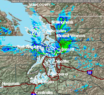
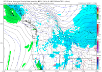
Clearly our heavier models are verifying, and then some. Most locations in Western Washington have met if not surpassed expectations for snowfall accumulations. The exception to this being extreme S/SW Washington, where they haven't reached their event timing yet. Many locations have exceeded 5" of snow, and some are approaching 10". As of 3:30am, I've already reached the top limit of my snow predictions (2"), with at least another inch set to fall. Coupled with the snowfall, extremely hostile conditions are being reported up in Bellingham, with temperatures in the teens and wind chills bottoming out below zero. Bellingham also just recorded a gust of 56mph, which is just dandy. Sometimes forecasts bust. Occasionally they bust in our favor. Like this time.

Official Forecast for Tonight

Image
Edit 1:45pm: snowflakes are falling throughout North Seattle, and precipitation is filling into the Puget Sound with plenty of precip offshore. Forecast on track so far. Well it took long enough. Just three months into winter, we find ourselves in the position to see some snow throughout the region. The pattern doesn't seem all that conducive for any widespread snow accumulations at first glance, however the potential for a decent snowfall does indeed exist for much of the Puget Sound lowlands. Let's start off with this morning's convergence zone: It is quite firmly planted in the Everett region for now, and will likely stay there for most of the afternoon. This feature is being brought about not by air diverging around the Olympics and meeting back in the Puget Sound, but rather by Arctic air pouring out of the Fraser River valley and meeting with southwest flow wrapping around our ULL. This is illustrated by the obvious difference in temperature between the

Detailed Thoughts on Upcoming Snow Event

Image
Superbowl 51, two years ago. With less than four minutes to go in the third quarter, the Falcons punt the ball away to Tom Brady after burning several minutes of clock crucial to the Patriots, whilst they lead 28-3; a seemingly insurmountable lead only matched by Seattle two years prior and Dallas in 1994. Atlanta is already celebrating, justifiably. Impartial to the incredible, inconceivable comeback about to ensue, I lay motionless beside my dining room, waiting for a sign. Any sign. It's 34F outside. Locations 500' and higher above sea level are getting pounded, and here I am, stuck in the lowlands, watching an equivalently inconceivably marginal drizzle taunt me. That day, I missed the greatest Superbowl of all time. And I got 1.5" of snow out of it; the lowest total in all the lowlands. Issaquah, just a half an hour's drive away, received more than 10". It is the single greatest meteorological robbery I have ever experienced. Ominously, the Patrio

Typical Hiatus and the Upcoming Snow Event

Image
I still exist! My life in the past month has been a barrage of holiday plans, schoolwork, and, well... a disinterest in weather. And it's not like you can blame me, either. This winter has been one of the most boring in recent memory for many snow fans across the region. Cold snap after cold snap have slid east of the Rockies, leaving only a taste of what we've been missing; bringing in northwest flow aloft. The lack of any sort of wintry weather that our region has been experiencing is not only uncharacteristic, but extremely difficult to achieve. Per @KSeattleWeather on twitter, we have to go back to 1991 to find a winter where not even a single flake of snow found its way into the heart of the city. Many of us have been thinking this is the next one. After all, it's almost February. As of now, we are receiving the same amount of solar energy that we would normally get in mid-November, and our days aren't getting any shorter. Facing the month-left deadline (r

The Wind Situation Tomorrow

Image
Coming not even 48 hours off the heels of a strong tornado, mother nature is throwing us another curveball this week with a rather potent windstorm. Development is well underway, and models are so far verifying wonderfully. Hopefully that will last. Satellite shows the initial spin developing within the sea of clouds over the Pacific this evening. This broad area of enhanced lift and moisture will further coalesce and organize into a tight-knit closed-core low pressure system overnight, further strengthening until bottoming out around +-980mb as it makes landfall somewhere along the southern end of Vancouver Island late morning tomorrow. As the core moves inland, pressure gradients will quickly spike in spectacular fashion, and as such, winds will spike along with this gradient. As expected, complications have arisen with the model's handling of the low's structure, because meteorologists can't have good things. The NAM says "Windy! Woooooo!" The E