Typical Hiatus and the Upcoming Snow Event
I still exist!
My life in the past month has been a barrage of holiday plans, schoolwork, and, well... a disinterest in weather. And it's not like you can blame me, either.
This winter has been one of the most boring in recent memory for many snow fans across the region. Cold snap after cold snap have slid east of the Rockies, leaving only a taste of what we've been missing; bringing in northwest flow aloft. The lack of any sort of wintry weather that our region has been experiencing is not only uncharacteristic, but extremely difficult to achieve.
Per @KSeattleWeather on twitter, we have to go back to 1991 to find a winter where not even a single flake of snow found its way into the heart of the city.
Many of us have been thinking this is the next one. After all, it's almost February. As of now, we are receiving the same amount of solar energy that we would normally get in mid-November, and our days aren't getting any shorter. Facing the month-left deadline (roughly February 10th) for our best snow chances, the sun rising in the sky, and oppressive El Niño conditions, many of us (including me) have been feeling that this isn't going to be our year, and have been preparing for summer thunderstorms and crimson sunsets.
Until yesterday...
Midday yesterday, our best weather models all synchronously underwent a radical change in our weather pattern in the Medium range outlook.
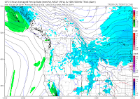
Here is the 12z Tuesday timeframe verifying 12z next Monday:
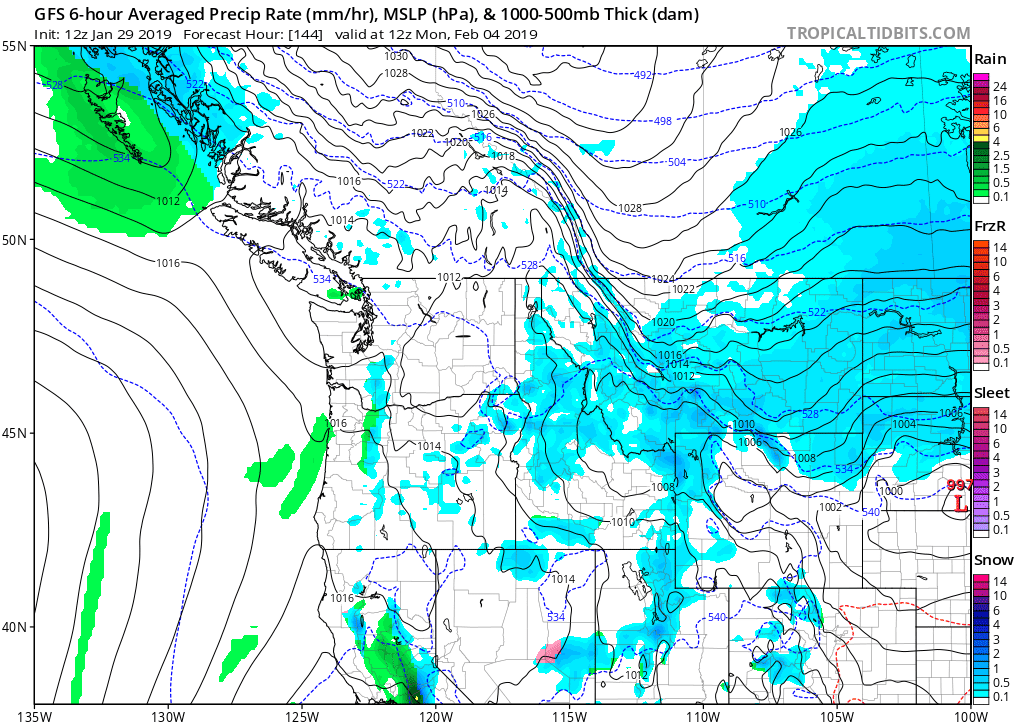


Now the 00z Wednesday:


Before I dive into this upcoming event, I would like to remark my appreciation for the improvements made on the FV3. That model, as well as the ECMWF, were the first to pick up on the atmospheric nuances in the northern Pacific that will eventually dive our trough down. This model is really exciting for American meteorology.
Let's discuss the cogs operating behind this event, and what the GFS and other models missed.
This event is being driven by a plunge of arctic air, not so unlike the one currently afflicting the midwest right now, except this time it's headed for our beloved Canadian friends in the Rockies. Speaking of those poor bastards, they'll have to endure temperatures well below zero (Fahrenheit) and strong winds. Tyler on @50ShadesofVan is confident they'll see some really wacky, record cold. I concur.
Next, we need to squeeze that stubborn Canadian cold air out of those cracks in the mountains (namely, the Fraser River Valley). This will be accomplished rather conventionally, via an upper level low waltzing itself down the coast and making landfall somewhere near the locales of Astoria and such; sucking the cold air out through differences in pressure.
The timing of the arrival of cold air is unclear this far out, but there is a decent chance that it will show itself a good few hours before we run out of precipitation. Should this occur, Seattle proper could escape with a coating of white. Before you get all excited, keep in mind that Seattle could also receive sufficiently cold air hours after the precip ends. For now, I will leave these details untouched.
Now what were the models missing before yesterday afternoon?
Upon brief large-scale observation, the answer is clear, and beautiful as well. It demonstrates the butterfly effect perfectly. In short, it all had to do with the handling of a system all the way up in the Aleutian Islands.
Upon comparing the 12z and 00z runs of the GFS, I found that the similarities far outweighed the differences.


Both had a developing elongated trough positioning itself off the coast of British Colombia, with cold air plunging southward into the interior Canadian Rockies. The differences arose with the handling of the front in the Aleutian Islands, way up there in the upper left corner.

Both show the front splitting, with the northern branch becoming a negligible shortwave dying somewhere in central Alaska, and the southern branch becoming more of a pronounced identity of a low pressure system in the gulf near Anchorage.


The 12z GFS (and runs prior) had made the southern branch low too strong. The low pressure system bottoms out at 993mb before becoming a strong shortwave in the Canadian Rockies; forcing the continental air to our north and east away from us.


Runs since have the low much weaker, bottoming out around 1001mb. The weakness of the low allows it to lose its identity and be absorbed by the Polar Jet. This energy, and its associated cold air, is captured and pulled into the region by our low off the coast.
Seeing niches like these in our model runs remind me of just how unpredictable our weather can be. This sudden change in our models should serve as an example of why we shouldn't trust model runs outside of the five day range. Hell, I'm not even completely convinced about our snow chances Sunday.
Nonetheless, Monday will be a cold one. Highs will struggle to get above 35F in most places, and many, especially up north near the border, could stay below freezing all day Monday, and even into Tuesday.
Something to watch as we get into the early week is strong Fraser Outflow winds affecting Bellingham and co. Gusts could exceed 40mph. Such speeds are capable of knocking over furniture and causing sporadic power outages, especially with the potential for snow on the trees.
Most importantly, piping should be turned dry. Burst pipes, as many of you know, are a nightmare.
Further out, more snow chances are possible. But that isn't for a while.
More updates later.

Comments
Post a Comment