The Wind Situation Tomorrow
Coming not even 48 hours off the heels of a strong tornado, mother nature is throwing us another curveball this week with a rather potent windstorm.
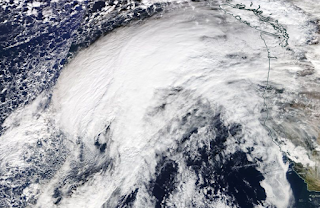
Satellite shows the initial spin developing within the sea of clouds over the Pacific this evening. This broad area of enhanced lift and moisture will further coalesce and organize into a tight-knit closed-core low pressure system overnight, further strengthening until bottoming out around +-980mb as it makes landfall somewhere along the southern end of Vancouver Island late morning tomorrow.
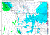
As the core moves inland, pressure gradients will quickly spike in spectacular fashion, and as such, winds will spike along with this gradient.
As expected, complications have arisen with the model's handling of the low's structure, because meteorologists can't have good things.
The NAM says "Windy! Woooooo!"
The EURO says, "What the NAM is having, but a little less hot sauce."
The GFS says, "I'm unreliable!" because screw resolution, that's why.
The HRRR says, "HURRICANE!!!.....but only in Everett. Breezy elsewhere."
And other models range from mild breezes to a region-wide state-of-emergency as society collapses and civil uprisings occur in the aftermath.
As per usual, run-to-run consistency has only just began to form, with minor inflections on the low's track not adding up to much in the grand scheme of wind strength at this point. As of now, I think it's safe to formulate a forecast for the region.
Greater Seattle Area:
Pressure gradients won't max out here quite as strong as they will in the northern Snohomish County area. However, they will still be quite enhanced as a sort of "piece" (if you will) of the low will separate from the main core and drift through the strait. This will create a sharp area of strong-severe winds in the north-central Puget Sound, the peak of which will likely place itself just north of Seattle. The Seattle area still is, however, in the wild-card region for this feature and could be right on top of it should the forecast go awry.
General bets are 25-35mph sustained with gusts to 45-55mph during the peak of the event. A few errant gusts could validate the warning given out by the National Weather Service, so keep a look out on the wind reports in the area.
Southern Puget Sound:
Pressure gradients here will be the weakest of the region, and areas outside of the foothills and beaches will struggle to get up to 45mph with their gusts. The potential winds here are still very high here, so keep watch on what is going on.
Northern Puget Sound:
This is likely where the main action will be. Pressure gradients really spike here locally. Beaches and exposed hilltops/outcroppings here should generally be avoided. Gusts here could easily breach 70-75mph in the most exposed areas; potentially strong enough to knock some people over and definitely strong enough to make walking difficult.
Sustained winds will vary from 25-45+mph, with gusts ranging from 55-75+mph depending on where you are.
To note: the whole region will experience ferocious winds around 1,000ft above the ground. Exposed mountain tops will be in the midst of this, and those severe wind gusts can make it to the surface in heavier showers. Often, the worst winds don't come when pressure gradients are highest, but rather when heavy, organized bands of showers drag strong wind gusts to the surface. The air behind the front tomorrow will be marginally unstable, so be on the lookout for some of those showers.
Most importantly, stay safe and watch the observations out there. It'll be a good one tomorrow.
 |
| Development is well underway, and models are so far verifying wonderfully. Hopefully that will last. |
As the core moves inland, pressure gradients will quickly spike in spectacular fashion, and as such, winds will spike along with this gradient.
As expected, complications have arisen with the model's handling of the low's structure, because meteorologists can't have good things.
The NAM says "Windy! Woooooo!"
The EURO says, "What the NAM is having, but a little less hot sauce."
The GFS says, "I'm unreliable!" because screw resolution, that's why.
The HRRR says, "HURRICANE!!!.....but only in Everett. Breezy elsewhere."
And other models range from mild breezes to a region-wide state-of-emergency as society collapses and civil uprisings occur in the aftermath.
As per usual, run-to-run consistency has only just began to form, with minor inflections on the low's track not adding up to much in the grand scheme of wind strength at this point. As of now, I think it's safe to formulate a forecast for the region.
Greater Seattle Area:
Pressure gradients won't max out here quite as strong as they will in the northern Snohomish County area. However, they will still be quite enhanced as a sort of "piece" (if you will) of the low will separate from the main core and drift through the strait. This will create a sharp area of strong-severe winds in the north-central Puget Sound, the peak of which will likely place itself just north of Seattle. The Seattle area still is, however, in the wild-card region for this feature and could be right on top of it should the forecast go awry.
General bets are 25-35mph sustained with gusts to 45-55mph during the peak of the event. A few errant gusts could validate the warning given out by the National Weather Service, so keep a look out on the wind reports in the area.
Southern Puget Sound:
Pressure gradients here will be the weakest of the region, and areas outside of the foothills and beaches will struggle to get up to 45mph with their gusts. The potential winds here are still very high here, so keep watch on what is going on.
Northern Puget Sound:
This is likely where the main action will be. Pressure gradients really spike here locally. Beaches and exposed hilltops/outcroppings here should generally be avoided. Gusts here could easily breach 70-75mph in the most exposed areas; potentially strong enough to knock some people over and definitely strong enough to make walking difficult.
Sustained winds will vary from 25-45+mph, with gusts ranging from 55-75+mph depending on where you are.
To note: the whole region will experience ferocious winds around 1,000ft above the ground. Exposed mountain tops will be in the midst of this, and those severe wind gusts can make it to the surface in heavier showers. Often, the worst winds don't come when pressure gradients are highest, but rather when heavy, organized bands of showers drag strong wind gusts to the surface. The air behind the front tomorrow will be marginally unstable, so be on the lookout for some of those showers.
Most importantly, stay safe and watch the observations out there. It'll be a good one tomorrow.


Comments
Post a Comment