The Problem With the FV3...
While I was browsing Twitter today, I came upon a post regarding the FV3, our country's flashy, new upgrade to it's outdated and sloppy older brother, the GFS. The post mentioned how there was a possibility of a white Christmas in the Seattle area, and that we should watch out for slick roads and gridlocked traffic. Groaning, I opened Tropical Tidbits in a fresh new tab and awaited the results. You see, the problem isn't what I saw; no...
The problem is that I knew what I was going to see.
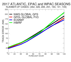
For about the third week in a row, NOAA's shiny new toy has dispensed yet another perplexing and intriguing output. On paper, the FV3 has preformed fairly well. At its core, the model has done well with track placement, particularly with cut-off lows like tropical storms, especially in the shorter range of its forecast time slot.
The problem lies with its ability to handle dammed cold air: something that just so happens to occur quite a bit around here.
On just about every model run, the thing has treated nippy air like a dead-weight. Over and over again, it repeats the same tale of entire Pacific midlatitude cyclones succumbing to the raw might of a 6mb pressure gradient between Seattle and Bellingham, often multiple times per run.
Now, look... I'm not usually one to complain about incorrect mid and long-range model runs. That is to be expected, especially when dealing with more diluted terrain features/lower resolutions during the stormiest time of the year. I get that. But the sheer amount of overrunning events that the FV3 puts out is astounding, to say the least. Take Christmas for example:
The problem is that I knew what I was going to see.
For about the third week in a row, NOAA's shiny new toy has dispensed yet another perplexing and intriguing output. On paper, the FV3 has preformed fairly well. At its core, the model has done well with track placement, particularly with cut-off lows like tropical storms, especially in the shorter range of its forecast time slot.
 |
| The FV3 has preformed astoundingly with hurricane forecasts; acting as a significant upgrade over the GFS and the failed HMON. |
On just about every model run, the thing has treated nippy air like a dead-weight. Over and over again, it repeats the same tale of entire Pacific midlatitude cyclones succumbing to the raw might of a 6mb pressure gradient between Seattle and Bellingham, often multiple times per run.
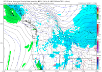
Now, look... I'm not usually one to complain about incorrect mid and long-range model runs. That is to be expected, especially when dealing with more diluted terrain features/lower resolutions during the stormiest time of the year. I get that. But the sheer amount of overrunning events that the FV3 puts out is astounding, to say the least. Take Christmas for example:
On the right is the GFS, the left the FV3. Both have a similar solution, with cold air in place, and a disturbance approaching land with precipitation. Notice how the FV3 model unrealistically retains the cold air, giving us a White Christmas. Disappointing.
Again, this isn't to say the model is bad. It is structurally and conventionally a great model. It just has its flaws in a few key areas, making armchair weather enthusiasts go ballistic over the raw output.
Please think critically of what you see.


Comments
Post a Comment