Posts

INSANE EF2 Tornado in Port Townsend

Image
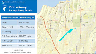
Sometimes things happen that rejuvenate your hobbies. Things like what happened on Tuesday remind me of why I love weather so goddamn much. In the early afternoon of Tuesday, a strong tornado touched down in the southern outskirts of Port Townsend. The damage caused by the tornado was uncharacteristic for the Puget Sound region, especially with the mild shear and shallow convection that followed the front. I was blown away when I saw the storm on radar. Without even looking, I could tell the presence of rotation within the cell based on the hook echo-esque structure. You heard me right. No words... Ears perked, I tapped the HELL out of the velocity mode, nearly cracking my phone screen. My jaw nearly hit the floor. There was like a 90% chance of a tornado being in that thing. Surreal. CLEAR rotation. Something out of Kansas. The damage, as mentioned, far outdid the previous tornado that brushed the region. That one was a wimpy EF0 that harassed a trailer park with 7...

The Problem With the FV3...

Image
While I was browsing Twitter today, I came upon a post regarding the FV3, our country's flashy, new upgrade to it's outdated and sloppy older brother, the GFS. The post mentioned how there was a possibility of a white Christmas in the Seattle area, and that we should watch out for slick roads and gridlocked traffic. Groaning, I opened Tropical Tidbits in a fresh new tab and awaited the results. You see, the problem isn't what I saw; no... The problem is that I knew what I was going to see. For about the third week in a row, NOAA's shiny new toy has dispensed yet another perplexing and intriguing output. On paper, the FV3 has preformed fairly well. At its core, the model has done well with track placement, particularly with cut-off lows like tropical storms, especially in the shorter range of its forecast time slot. The FV3 has preformed astoundingly with hurricane forecasts; acting as a significant upgrade over the GFS and the failed HMON. The problem lies wi...